Below are the questions from the Q&A session during the April 10th webinar: Field Data Collection With Smartphones, Tablets, and Lasers. Similar questions have been grouped together. The list has also been grouped by topic: GPS accuracy – TruPulse Lasers – The GeoJot+ App – Offline Data Collection – Mapping & Reporting –GeoJot+ Pricing.
Please check out our blog for more information about smartphone/tablet technology, GPS, cameras, field data collection, and photo mapping.
GPS ACCURACY
Q: What is the accuracy of GeoJot+?
Q: Is 33′ the best accuracy?
Q: what determines the horizontal accuracy for the gps?
Q: What is the best case accuracy for smart phone pictures?
Q: Does the accuracy use the mobile device i.e. iPhone internal GPS?
Q: Which is the accuracy of the application on android device?
A: GeoJot+ uses the GPS chip in the mobile device (smartphone/tablet) as the primary source of GPS information, the chip is not dependent on cell service in Android devices, so photos collected and processed with GeoJot+ should have a 3 to 5 meter accuracy. The readings can be more or less accurate but this is the average. On the Android Juno T41(Juno 5) the accuracy is 2-4 meters.
Q: Is the GPS accuracy based on your cell phone or the laser?
Q: How accurate is the GPS accuracy reporting algorithm in GeoJot +?
Q: so you do not need to take photo to take the GPS coordinate from the laser?
A: GeoJot+ receives GPS information from the GPS chip in the smartphone or tablet. The laser does not have a GPS chip. You need to take a photo to store the distance the bearing from the laser, along with the GPS from the smartphone or tablet.
Q: During the demonstration, the lower left hand of the photo stated a GPS accuracy of +39′. What is the geospatial accuracy, ie state plane coordinates, on each logged point.
A: In the GeoJot+ app, coordinates can be displayed in Degrees minutes seconds – or – degrees minutes – or – decimal degrees -or – UTM. You can also choose to show Military Grid Reference System (MGRS). You can further convert the data into different datum and projections using GeoJot+ Core in the office. Average accuracy for the Android smartphones and tablets is 3-5 meters.
Q: What is the highest positional accuracy that can be achieved?
A: 3-5 meters is the average accuracy from a smartphone or tablet. Higher accuracy can be achieved by using data from a higher accuracy GPS unit like a Trimble Geo6000. Accuracy is only limited by the GPS unit. Please see questions immediately below for details on how this can be done.
Q: Do you have a technology/ device to increase GPS accuracy for cell phone
Q: Are there any better spatial accuracy options available, sub-meter?
Q: What can be done to improve the GPS accuracy of a smartphone? (i.e. post processing)
Q: How can I Increase accuracy to less to one metre?
Q: Can Differential GPS be used with the laser and GeoJot?
A: You can increase the accuracy of the GPS reading by using a higher accuracy external GPS unit. There are 2 ways that GeoJot+ can work with other GPS receivers. Out in the field, the GeoJot+ app can accept data from a more accurate unit like the Geo6000 if Bluetooth is available on the GPS unit. The GeoJot+ app will use the coordinates from the GPS receiver instead of the internal GPS reading…..OR…..Back in the office, you can the desktop component, GeoJot+ Core, to re-geotag the photos with more accurate information using the Geotag tab. Using GeoJot+ Core, the new GPS coordinates will overwrite the coordinates from your smartphone or tablet. GPS data can from a Trimble unit can be Post Processed before it is imported in Core, typically using a program like Pathfinder Office.
Q: Can you have multiple items bluetoothed to android device? Seeing that I would want to bluetooth a laser as well as a GPS unit.
A: Yes, GeoJot+ can receive Bluetooth input from a GPS receiver and laser at the same time.
Q: Can i used trimble 5800 head to the android?
Q: Also, can it pair with RTK enabled high accurate GPS device?
A: If the unit has Bluetooth then yes, it can be used with the Android device running GeoJot+.
Q: Accuracy between ipad GPS v/s Trimble Juno?
A: Juno has 2-4 meter accuracy, but the antenna and GPS is much more sensitive, so it will be better in forests and urban canyons.
Q: What is the link between laser accuracy and android gps accuracy?
Q: What is the accuracy of the system? with the Tru-Pulse you said + or – 1 foot when you and the GeoJot app, what is the accuracy?
A: The accuracy of the GPS reading is dependent on the GPS chip in the mobile device (smartphone/tablet). That accuracy is generally 3-5 meters. The accuracy of the TruPulse is +/- 1 ft. .
Q: If the GPS accuracy for GeoJot is only about 12 ft then the coordinates calculated for the laser reading would also only be about 12 feet. Is that correct?
A: IF the accuracy of the GPS was 12 ft, and the accuracy of the TruPulse is +/- 1 ft then the accuracy of the entire system would be +/- 13 feet.
Q: what is the elevation accuracy typically?
A: Usually twice the GPS accuracy, so 6-10 meters.
TRUPULSE LASERS
Q: Can the laser get data during rainy, foggy days or dimly lit areas?
A: It all depends on how dense the rain & fog conditions are. The TruPulse does have some functions to measure in these types of conditions: Filter mode to be used with a reflective target; Farthest mode which once the initial target is acquired, the TruPulse can acquire additional targets. The MULTI indicator denotes that additional targets have been acquired. The farthest acquired target always appears in the Main Display. If one cannot see the target, the TruPulse will not be able to measure to the target.
Q: Can the TruPulse be used for measuring buildings and structures from all points?
A: The TruPulse can measure the heights and widths of buildings from a remote distance.
Q: COST OF LASER?
A: Please contact a local LTI Authorized Dealer for more pricing information. A local LTI Authorized Representative will be in contact who can provide a price quotation.
Q: Can you please expand on the precision of the True Pulse device.
A: The TruPulse automatically provides the best accuracy and acquisition distance to a given target. Maximum measurement distance varies with target quality and environmental conditions. When shooting to a non-reflective target, the maximum measurement distance is approximately 1,000 meters (3,280 feet). When shooting to a reflective target, the maximum measurement distance is approximately 2,000 meters (6,560 feet).
When selecting a target, you should consider the following:
• Color: The brighter the color, the longer the range.
• Finish: Shiny finishes provide longer range than dull finishes.
• Angle: Shooting perpendicular to a target provides better range than shooting to a target at a sharp angle.
• Lighting Conditions: Overcast skies increase the unit’s maximum range, and sunny skies decrease the unit’s maximum range.
Target quality has an effect on the precision of measurements. A high quality target will result in a measurement that includes one decimal place (tenths). A low quality target will result in a measurement that is a whole number.
Distance Accuracy: ±1 ft (±30 cm) to high quality targets ; ±1 yd (±1 m) to low quality targets
Q: Can you set the height of the laser before shooting?
A: There is not a way to set the height within the TruPulse. If you using it with a GPS unit to collect laser offset point, the GIS software does have a way to set the height of the TruPulse from the GPS unit.
Q: Could the laser shoot the center of a manhole cover (say 20′ away) from the side walk?
A: The TruPulse beam diameter increases in size as the distance increases. Example the beam diameter at 100ft target is 5″ inches in diameter. The TruPulse has “thru-the-lens” viewing, eliminating parallax issues so you know the laser energy is traveling directly along your line of sight to the target.
Q: Can the laser measure to the center of a Man Hole cover? I would be using a Trimble GeoXH to shoot covers.
A: The TruPulse integrates with the Trimble products & GIS software to capture laser offsets. laser offset webpage; One can measure to the center of a man hole cover; should be aware of the distances to the target, the TruPulse beam diameter increases in size as the distance increases. Example the beam diameter at 100ft target is 5″ inches in diameter. The TruPulse has “thru-the-lens” viewing, eliminating parallax issues so you know the laser energy is traveling directly along your line of sight to the target.
Q: Is the laser accuracy survey grade?
Q: What is the best case accuracy for the laser units?
A:The TruPulse models range accuracy is considers resource (mapping) grade accuracy, not survey grade. The range accuracy is +/- 1ft (30cm).
Q: do you have a rebate program to assist with upgrade to newer laser
A: At this time LTI does not offer a rebate program.
Q: How accurate is the system when shooting target from a moving platform, i.e boat to shoreline?
A: The TruPulse Distance accuracy: ±1 ft (±30 cm) to high quality targets ; ±1 yd (±1 m) to low quality targets; The TruPulse is best used when standing still to take the measurements.
Q: Can the laser penetrate water? I would like to use this to measure underwater structures.
A:The TruPulse uses pulse technology to measure to objects, it cannot penetrate water.
Q: I want to be able to show water, lines and either draw or paint the ground can I laser that:
A:The TruPulse cannot paint the ground, it only measures distances & angles.
Q: Is there a hardwire serial cable available for non Bluetooth devices:
A:All TruPulse models have a serial port for hardwired communication. LTI offers a wide variety of serial cables.
Q: Pricing of laser?
A: Please contact a local LTI Authorized Dealer for more pricing information. A local LTI Authorized Representative will be in contact who can provide a price quotation.
Q: What is the maximum distance from laser to object?
A: The TruPulse has a range of: Max to non-reflective targets 3,280 ft (1,000m); Max to a reflective target 6,560 ft (2,000m).
Q: Does the distance from laser to object affect reading accuracy?
A: The TruPulse automatically provides the best accuracy and acquisition distance to a given target. Maximum measurement distance varies with target quality and environmental conditions. When shooting to a non-reflective target, the maximum measurement distance is approximately 1,000 meters (3,280 feet). When shooting to a reflective target, the maximum measurement distance is approximately 2,000 meters (6,560 feet).
When selecting a target, you should consider the following:
• Color: The brighter the color, the longer the range.
• Finish: Shiny finishes provide longer range than dull finishes.
• Angle: Shooting perpendicular to a target provides better range than shooting to a target at a sharp angle.
• Lighting Conditions: Overcast skies increase the unit’s maximum range, and sunny skies decrease the unit’s maximum range.
Target quality has an effect on the precision of measurements. A high quality target will result in a measurement that includes one decimal place (tenths). A low quality target will result in a measurement that is a whole number.
Examples:
• 120 feet (meters / yards) indicates a measurement was made to a low quality target.
o Accuracy: ±1 yd (±1 m).
• 120.0 feet (meters / yards) indicates a measurement was made to a high quality target.
o Accuracy: ±1 foot (±30 cm).
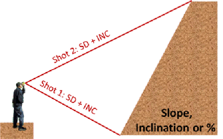
Q: You show straight upright poles, but what about a sloped roof?
A: The TruPulse models have a function called Missing Line, where is can measure the slopes. GeoJot+ can now capture that missing line data.
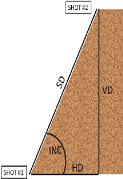
The Vertical Missing Line Routine: Displays HD, VD, SD, INC between two remote points.
The Vertical Missing Line Routine calculates distances and angles to describe the relationship between two points in two-dimensional space (connecting vector). This routine is ideal for remote slope determinations and changes in elevation from one location.
The simple routine prompts you to take two shots to targets: “Shot 1” and “Shot 2”. The TruPulse uses the results to calculate four variables between the two points: slope distance, inclination, horizontal distance, and vertical distance as shown in figure to the right.
• HD: Horizontal Distance: Horizontal component of the missing line.
• VD: Vertical Distance: Change in elevation between point #1 and point #2.
• SD: Slope Distance: Length of the missing line.
• INC: Inclination between point #1 and point #2.
Q: Will the Laser work through Glass? i.e. Aerial Observation from helicopter?
A: The TruPulse models can measure range through glass. It will depend on how opacity the glass is. Using a TruPulse model in a helicopter does has some risks: if using the TruPulse 360 models the compass measurement will not be accurate due to the magnetic interference’s from the helicopters metal.
Q: What is the laser measurement accuracy?
A: Distance: ±1 ft (±30 cm) to high quality targets ; ±1 yd (±1 m) to low quality targets
Inclination: ±0.25 degrees
Azimuth: ±1 degree
Q: When will the TruPulse contain onboard GPS?
A: There are no plans to have a GPS built on board of the TruPulse model.
Q: Is Laser true pulse compatible with Trimble device?
A: Yes
Q: What is the power of the laser? Is there a risk of eye damage ?
A: The TruPulse models meets FDA eye safety requirements and is classified as eye-safe to Class 1 limits, which means that virtually no hazard is associated with directly viewing the laser output under normal conditions. As with any laser device, however, reasonable precautions should be taken in its operation. It is recommended that you avoid staring into the transmit aperture while firing the laser. The use of optical instruments with this product may increase eye hazard.
Q: With the laser will this allow shot of one pole and rotation in degrees to another adjacent pole?
A: The TruPulse 360 models have a compass built in to measure azimuths in degrees. If being used with a GPS unit to collect laser offset points, once can measure to one pole to collect the position data, then rotate to another pole to collect the position data.
THE GEOJOT+ APP
Q: can i set a limit on the size of the photo, e.g. 5MP?
A: Yes. Under camera > settings, you can choose the photo capture size. Using a smaller size will decrease the storage requirement for the photos, and increase the upload speed to Dropbox.
Q: Can this work with QR codes as it does for bar codes?
Q: Do you use camera to read QR code/bar code?
A: Yes, GeoJot+ will work with 2D barcodes, 3D barcodes, and QR codes.
Q: Can I add new item into predefined item list? Like I find new tree types which doesn’t exist in predefined list, I want to add into item as default.
A: Yes, you can add a new item to a list. You can do that out in the field on the mobile device. You can also add it back in the office using GeoJot+ Core. Adding the item in Core, you could make it the default selection.
Q: can the editing function be turned off or disabled?
A: Yes, you can lock a list so that it cannot be edited in the field.
Q: for some application the user should never change field collected data. If we want the untouched data to be maintained we would want the editting functions disabled or original information to also be maintained.
A: No
Q: Can you have the data repeat or auto fill the data, most light data is the same and you fill it out the first time and automatically populate the next with the ability to change any discrepancies.
A: Yes, you can do that. When you are creating your list you have the option to set default values for each attribute. If you set a default value, that is the data that will prepopulate the list every time you bring it up in the field. As you collect your data, you can choose to accept the default or you can select another value.
Q: Can data be collected without taking a photo?
A: You must take a photo, however, we have several customers who take a photo of the ground and then enter the data. They use the coordinates and the attribute data but they do not need/use the photo.
Q: Also, can multiple photos be associated with one set of attributes?
Q: Will this support multiple photographs at a single way point?
A: We expect this functionality will be available in June of this year.
Q: Can you create a multi drop down list
Q: Is it possible to collect relational data with GeoJot or is it restricted to a single set of attributes per location?
A: We do not currently support nested (hierarchical) lists. It is currently limited to single set of attributes per location.
Q: can data be received from a remote office on real time
A: Data from GeoJot+ can be uploaded to the cloud and automatically downloaded to a remote office in real time. Lists can be distributed to the field in real time. However, outside of lists, data cannot be pushed to the mobile devices.
Q: Can precaptured data be loaded in a similar way as the attribute list? Example, a data capture is undertaken today with photos and asset condition recorded. In six months time can an officer undertake another condition assessment with the previous data captured available on their device and available to update via geojot?
A: No
Q: On a customized Form, is there a limit to the number of fields, or a limit to the unique values in a field pull down list?
A: You can create 40 fields in addition to the GPS and laser data. There is no limit to the number of unique values in a pull down list.
Q: Are the field parameters from a template or are they custom created? What software did you use to create the database?
Q: Imports from .xls is nice! Any other formats supported? .mdb etc.. (We support CSV as well)
A: We used GeoJot+ Core, the desktop processing software to create the data collection list that was distributed to the field teams. During the demonstration we imported an excel list to create the field data collection form. You can also type in the information to create the data collection list. Last, there is a script that will allow you to import a list directly from an ArcGIS Geodatabase.
Q: Can you import ArcGIS shapefiles/feature classes into application for display in phone and make them editable?
A: No
Q: can we use / download background spatial images for off-line use of the device?
A: Not at this time.
Q: Is the laser unit required to operate/activate the application on an Android/Apple device?
A: The laser unit is not required. The laser adds distance, bearing and height of the object.
Q: can GeoJot collect and attribute video
A: GeoJot+ does not collect video data with attributes at this time.
Q: can I see what I collect in the field on a map like one would see in Trimble Juno or ArcPAD?
A: In the camera roll screen, there are 4 options for viewing your data – you can view individual photos, you can view an individual photo thumbnail with a map along with the first 3 attributes, you can view all the photos on a map, or you can view a thumbnail of the photo along with all the attributes.
Q: For Cloud option – Can ArcGIS Online be use in conjunction to share / transfer data between mobile device and desktop?
A: No
Q: What other cloud options are available outside DropBox?
A: Right now Dropbox is the only available option. Other cloud options could be implemented for a customer through GeoSpatial Experts professional services offerings.
Q: can your app sync the data with something other than the cloud, e.g. and external corporate database?
A: Yes, that could be implemented for a customer through GeoSpatial Experts professional services offerings.
Q: How about integration to other enterprise apps. Is it open, or does it have an API or other direct integration option?
A: GeoJot+ does not have an API, please contact John Clark directly if you would like to further discuss your needs around integration.
Q: Can users place a point on screen rather than use GPS?
A: Users can place a point on the screen rather than use GPS in the office using GeoJot+ Core. In the field the point will be placed using GPS but the user can move the point on the camera roll screen.
Q: Can you only record points or is there an option for polygons and lines as well?
Q: Can the GeoJott+ system collect line and area data?
A: GeoJot+ collects point data, not lines or polygons.
Q: In the UK we have a very good detailed mapping product called Ordnance Survey MasterMap and I tend to use this as an offline shp file optimised for mobile devices. Is there any plans to be able to work offline with background mapping. In many areas I work there is little data connections available so having a 3G data link to ArcGIS server doesnt always work?
A: No, not at this time.
Q: Also does it work in Android Devices such as Samsung Tablet 10.01
A: Yes
Q: Do you have a list of smart phones that work best?
Q: which android smartphone has highest accuracy levels?
Q: I wonder if anyone has tested the accuracy of a range of Smartphones in different situations and I wondered if you knew which provided the best accuracy?
A: We have had good results with the Samsung Galaxy 3, HTC One X, as well as Samsung Galaxy 7 and 10” tablets. We have received customer feedback on the following phones: Sprint’s Motorola Photon 4G – good GPS, good photos but no optical zoom. Samsung Galaxy Nexus 5 – mediocre photos and poor GPS. HTC EVO 4G Android 2.3.5 has good GPS but the compass in unreliable. The ZTE Optik – great size, good GPS but only 3G which means slower upload to the cloud. Please let us know if you have found devices that you do or do not like.
Q: how do you handle data collection on a sunny day? Can’t see the screen very well.
A: One option is to increase your screen brightness. It is generally set at at mid-range to extend battery life but increasing the brightness can improve your ability to read the screen in the sun. An anti-glare screen film may also provide some help. This is also a good parameter to consider as you are purchasing your mobile devices. Last, your GPS location is captured as soon as you take the photo, if you move to get better screen visibility for data entry after snapping the photo, it will not effect the GPS coordinates of your photos.
Q: Does GeoJot+ work on Windows Mobile Devices such as the Geo 6000?
Q: Does it support WM OS? Or a more accurate GNSS devices?
A: We have a beta version of GeoJot+ working on a Windows 6.5 device. Please contact John Clark at GeoSpatial Experts for more information.
Q: Does GeoJot+ work on Windows Mobile Devices such as the Nokia 920 phone? I looked for the app in windows but did not find one.
A: GeoJot+ has not been ported over to Windows 8 Mobile yet. A windows mobile version could be implemented for a customer through GeoSpatial Experts professional services offerings.
Q: any chance this system can work with windows RT?
A: No, GeoJot+ does not work with Windows RT. A Windows 8 RT version could be implemented for a customer through GeoSpatial Experts professional services offerings.
Q: is all this software web-based?
A: The GeoJot+ app is a software app developed for the Android and iOS (Apple) operating systems. The Administrator’s Dashboard is web-based software to manage your team’s licenses. GeoJot+ Core is PC based software for processing data to create maps, reports, watermarked photos and other output.
Q: do we need to have geoJot+ installed on our android phones / tablets?
A: Yes – to collect field data you need to have GeoJot+ installed on your smartphones and tablets.
Q: What about the phone’s power consumption? How many points can I shoot before my phone goes dead?
A: This is dependent on your smartphone or tablet as well as the battery you are using in that device. It is also greatly affected by other settings and programs on your device such as when the screensaver kicks in, if you are using Bluetooth, etc. Please see this blog post on energy consumption and extended life batteries. While this article refers to iPhone, the issues are often the same with Android.
Q: Can I share the recording of this webinar with the multiple municipalities that we work with so they can consider acquiring GeoJot for themselves? Put into follow up letter.
A: Absolutely, please feel free to share the link to the recorded webinar with colleagues that might be interested in collecting field data with GeoJot+ and TruPulse lasers.
Q: You mentioned that it was not as easy to hook but the Laser to an Iphone as an Android device. Can you please elaborate. Thanks
Q: Can you send an explanation of how using an iPhone will slow a person down? I need to decide if I need to invest in Android or if I can avoid that cost.
Q: what are the additional steps to get this to work with iphone?
A: Users are still able to collect data with existing TruPulse lasers and GeoJot+ running on an iPhone.
US Night Vision makes a bracket which allows user to attach a TruPulse laser to their iPhone. With the phone attached to the laser, users take measurements with the laser and then take their photo using GeoJot+. Because the laser is mounted to the iPhone, the user not only captures the subject of their photo, they also capture all the information from the laser scope shot. Later when the user is processing the data through GeoJot+ Core on their computer, they can look at the photos and transcribe the information from the laser scope into the attribute editor, adding it as an attribute stored in the images EXIF header and fully accessible in the processed ArcGIS, Google Earth, and Report output.
LTI will soon be releasing a new laser with Apple compliant Bluetooth.
Q: I have a Ricoh Caplio 500SE that has a GPS attachment. Can I use the ap with this camera as well as the laser?
A: The Ricoh 500SE does have data collection capabilities and can also accept data from the TruPulse laser via Bluetooth.
Q: is there any urban design companies using this software?
A: Yes. We have engineers, architects, planners, scientists, surveyors, using our software for urban design.
Q: how useful is this in fishery science
A: GeoJot+ is used for fish and animal counts at specific locations and habitat assessments.
OFFLINE DATA COLLECTION – LIMITED CONNECTIVITY
Q: will the application que the data for later upload if there is not cell service available?
Q: How functional is the sytem without Cloud access?
Q: In a disaster area where the cell coverage has been disabled, how will GeoJot work?
Q: What happens if you are in a remote area with no connectivity?
Q: What about data collection in areas where could not access cloud?
Q: How well will the real-time connection work in remote areas with no phone reception?
A: GeoJot+ will still capture photos, data, and GPS location without cell service / internet connection / WiFi. This is true for all mobile devices that have an internal GPS chip. We have never seen an Android device without an internal GPS chip. If you have chosen to use the cloud data transfer, GeoJot+ will queue the data and send it as soon as there is connectivity. There is also an option that allows you to send data only when you are in Wi-Fi range.
Q: Will this application work on mobile devices that aren’t activated on a cellular service so that that it can be synced when in wifi range?
A: Yes
Q: What’s the data usage like to send the data from a mobile device to the cloud?
A: That is dependent on what size pictures you are taking (you can set that in GeoJot+), how many pictures you are taking, and your carrier. There is also an option under the cloud settings that will allow you to send data only when you are in WiFi range.
MAPPING AND REPORTING
Q: can coordinaters be in decimil degrees? rather than DMS…
Q: Can we choose the projection system?
Q: Can co-ord system be in local system e.g. South African local co-oridnate system in meters – specific spheroid and datum?
A: Yes, yes, and yes. In the GeoJot+ app, coordinates can be displayed in Degrees minutes seconds – or – degrees minutes – or – decimal degrees -or – UTM. You can also choose to show Military Grid Reference System (MGRS). We have integrated Blue Marble Geographics into GeoJot+ Core for extensive datum and projection transformations while processing your data to create maps, reports, and database input.
Q: Can reports formats be modified to create a custom format?
A: When you create your reports in GeoJot+ Core you can save your formatting as a template and then apply that template to other data sets.
Q: I have the trial version; does it contain the custom desktop ArcMap base map option. I don’t see it on the static map tab as an option
A: In GeoJot+ Core on your computer, select the 6th tab – Shared Output Settings. On that screen you will see where you can set your background maps, in that section there is a button “Manage Custom Maps”. Click on that and you will be able to select your custom ArcMaps for use in your reports.
Q: As it can ESRI ArcMap with viewing the data and photos, can it work with AutoCAD Map3d?
A: Yes, you can create shapefile output from GeoJot+ and import that into AutoCAD Map3d.
Q: Looks like the watermarked location and location on the map is going to show where the photo was taken. Can you have the offset location imprinted on the photo instead?
A: Yes, you can have the offset location imprinted on the photo.
Q: what is the process to use google eaqrth dashboard with this program as shown on the demo
A: When processing your data in GeoJot+ Core, on the 7th and final tab “Select Output”, you select the Google Earth (.kml/.kmz) output type. After processing, click on the eyeball icon next to the Google Earth output and GeoJot+ will open an instance of Google Earth displaying your data.
Q: How are the photos linked within the Google Earth or Arcmap to the file location and specific file?
A: In Google Earth, the photos are always linked to the data. In ArcGIS, the photos can be linked or you can choose to embed the photos in a geodatabase as a BLOB.
Q: Does geojot send data to SDE server or ArcGIS Online?
A: GeoJot can send data directly to an SDE GeoDatabase, but not ArcGIS Online.
GEOJOT+ PRICING
Q: how much is the cost of geojot+
Q: Can you provide pricing on the app (website only has free trial)
Q: Can you repeat the enterprise pricing?
A: GeoJot+ is an annual subscription available in three tiers: Essentials, Team, and Enterprise. GeoJot+ is a full field data collection system which includes the app as well as GeoJot+ Core for process and output creation, and the Administrator’s Dashboard for managing the users.
A license for GeoJot+ Team (demonstrated in the webinar) is priced at $329/user/year. A license for GeoJot+ Essentials is priced at $219/user/year. Each license provides activations for the mobile app, the PC-based Core data processing and mapping application, and the web-based Administrator’s Dashboard. GeoJot+ licenses require an annual commitment but can be paid monthly. GeoJot+ costs less than $1/user/day.
GeoJot+ Enterprise includes quantity discounts for larger teams and the GeoJot 360 Implementation Blueprint. The implementation blueprint is delivered by GeoSpatial Experts Professional Services or an authorized reseller to organizations that want assistance with GeoJot+ processes, procedures, list authoring, training, workflow modification and design, database integration, or customized GeoJot+ functionality. Pricing for GeoJot+ Enterprise depends on the requirements of your organization. Please contact John Clark or your GeoJot+ reseller for more information.
Q: Do you have business partners in Africa?
A: Please contact John Clark to discuss this further.
Q: Will there be an academic/educational discount?
Q: Do you have educational pricing? What’s the cost of the laser? Thanks
A: Yes, we have created an education package that includes 10 GeoJot+ seats for $999 along with an educator’s kit. That is a 70% discount. Please contact us for more information.
Q: What are the costs to upgrade photo link to geojot?
A: Users can easily migrate your existing GPS-Photo Link licenses to GeoJot+. Please contact Linda Bobbitt via email or at 303.255.2908 for more information.
Q: Will photo link no longer be supported?
A: GeoSpatial Experts will continue to provide customer support for GPS-Photo Link. However, there will not be any new functionality or other changes to the program after July of 2013. At that time, GPS-Photo Link will become available as a subscription service, GeoJot+ Core. The annual cost for an existing customer will be the same as the current annual support & maintenance agreement for GPS-Photo Link, $149/year.
Other information
Read our case studies to see how people across the globe are photo mapping to solve business problems.
Sign up for a FREE 15 day trial of GeoJot+.


