Smartphones & Lasers for Utility Field Measurements
Recorded Webinar: Smartphones, tablets and laser rangefinders to capture utilities field data for utiltiles.
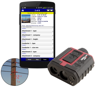
The days of height sticks and measuring wheels are almost gone, embrace the future. It’s time to consider advancements in measurement technology and electronic data collection that are affordable, require minimal training and can consistently produce reliable results. From pole audits to vegetation management, TruPulse laser rangefinders coupled with your smarpthones and tablets using the GeoJot+ app is the future. Check out the brochure and 2 minute video. The future is here.
 Increase worker safety
- Capture more accurate and consistent data
- Increase field productivity
- Create ArcGIS shapefiles and Geodatabases
- Share data through customized reports and Google Earth maps
- Feed information into your backend database
A TruPulse® laser coupled with GeoJot+ running on your smartphone, tablet or handheld GPS can be used for:
- Pole audits and co-location
- Attachment heights
- Mid-span clearance
- Span between poles
- Right-of-way vegetation management
- Proof of performance
Veiw the recorded webinar or for more detailed technical information, view the help videos for GeoJot+ with TruPulse lasers. For more information please contact an authorized reseller.


