From field data collection to final reports
Main Menu
Main Menu
Products
GeoJot+
GeoJot+ Core
Case Studies
Webinars
Industries
Natural Resources
Utilities
Engineering
Asset Management
Land Management
GIS/GPS
Oil & Gas
Case Studies
Help
Training Videos
Webinars
Online Help
FAQ
Tips & Tricks
Support Form
GeoJot+ Login
About Us
Corporate Profile
History
Media Coverage
Press Releases
Blog
Resellers & Partners
Customers
Contact Us
Posts Categorized:
Media Coverage
Home
Blog
Category: Media Coverage
Beauty of the Nikon COOLPIX P6000 bundle
Read More
GeoSpatial Experts Introduces New Photo-Mapping Software
Read More
Soil Burn Classification Maps Enhanced
Read More
GeoSpatial Experts is a known leader at providing software for managing photos and their GPS data
Read More
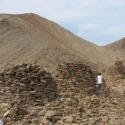
Archaeologist Maps Ancient Tombs in Oman with GPS-Photo Link Software
Read More
The underwater survey technique developed by the U.S. Environmental Protection Agency
Read More
GeoSpatial Experts Capabilities for GPS-Photo Link
Read More
New Tools Link GPS and Digital Cameras
Read More
GIS user can now see which side of the street the photo represents
Read More
Spiegleman Joins GeoSpatial Experts Sales Team
Read More
«
1
2
3
4
(current)
5
6
7
»