From field data collection to final reports
Main Menu
Main Menu
Products
GeoJot+
GeoJot+ Core
Case Studies
Webinars
Industries
Natural Resources
Utilities
Engineering
Asset Management
Land Management
GIS/GPS
Oil & Gas
Case Studies
Help
Training Videos
Webinars
Online Help
FAQ
Tips & Tricks
Support Form
GeoJot+ Login
About Us
Corporate Profile
History
Media Coverage
Press Releases
Blog
Resellers & Partners
Customers
Contact Us
Posts Categorized:
Media Coverage
Home
Blog
Category: Media Coverage
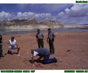
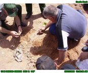
GPS photo-mapping in law enforcement
Read More
GeoSpatial Experts Introduces ArcPad Edition of GPS-Photo Link Software
Read More
Boosting Fieldwork Productivity with Photomaps
Read More
Ricoh 500SE GPS-Enabled Digital Camera
Read More
Ricoh Adds 3-Axis Compass to its GPS-Ready Digital Camera
Read More
Queensland Researchers Develop Photo-Mapping Technique for Benthic Habitats
Read More
Homeland Security Seminar Adopts GPS-Photo Link Software to Teach Critical Infrastructure Protection
Read More
Usage of GeoSpatial Experts’ GPS-Photo Link software
Read More
Punta Gorda, Fla., Deploys GPS-Photo Link for Asset Inventory and Damage Assessment
Read More
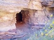
GPS-linked photography and GIS are used to record and analyze the details of a potential homicide
Read More
«
1
2
3
4
5
(current)
6
7
»