Laser Technology & GeoSpatial Experts Enhance the Mobile Mapping Experience
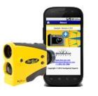
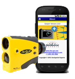
March, 15, 2013 - Two Colorado companies, Laser Technology, Inc. (LTI), manufacturer of the most popular handheld mapping laser and GeoSpatial Experts, a leader in photo mapping software announce their collaboration, seamlessly integrating their mobile mapping technologies together through Bluetooth®. The result is a complete field data collection solution that uses a smartphone or tablet in conjunction with an LTI TruPulse® 360B mapping laser. GeoSpatial Experts has recently released its new powerful app called GeoJot+ available for both Apple® (iOS) and Android® devices. GeoJot+ allows users to collect geotagged photos and capture descriptive attribute information for each photo. Since the TruPulse can sync its data string directly into the app, users can now collect remote coordinates of any feature and even capture height data from the same spot.
One shot from the laser measures slope distance, the degree of inclination and an azimuth value within 1 degree from True North. This raw data is then referenced from the user’s location and GeoJot+ generates the remote coordinates. Take a picture of any subject and the app automatically geotags the photo with the collected measurements and transfers it to the office in real-time via the cloud. In the office, users process the field data creating ArcGIS® or Google Earth maps, database output and reports showing the photo, the location on a map and the valuable attribute data that took seconds to collect.
Combining this powerful app with the fact that laser users don’t need to stand at every feature to collect location and height data saves a significant amount of time and increases worker safety. When attempting to collect field data around a busy street, within rough terrain or on private property, the value of taking laser offsets becomes priceless. Add that to GeoJot’s incredibly simple user interface and anyone with a smartphone or tablet can collect field data quickly and easily. The time savings alone will generate an immediate ROI.
The GeoJot+ app can run on iPhone (4S and up), iPad2 and up, iPod Touch, Android phones and cameras such as the Samsung Galaxy, as well as new Android GPS units such as the Trimble Juno 5 or Juniper Rampage. LTI’s TruPulse’s Bluetooth® module communicates only with the Android version, but Apple users can still leverage the benefits of the TruPulse laser with a few manual entries to the GeoJot+ app.
Geo Tactical Solutions, Western Data Systems, Cansel, Compass Tools, Electronic Data Solutions, Frontier Precision, Inc., and Precision Laser & Instrument are all active authorized dealers of the TruPulse lasers and complete field to office solution with GeoJot+. LTI and GeoSpatial Experts are both located in Colorado and have been business partners for over 10 years. For more information about this combination of mobile mapping technology, click here.


