Wetland Delineation
When Westwood Professional Services has a wetland delineation project, the GeoJot+ app running on their company-issued iPhones or iPads enables them to collect the data they need in the field. Rather than heading out with printed excel forms, pens and cameras, they use their mobile devices. This simplifies data collection and also data processing back in the office.
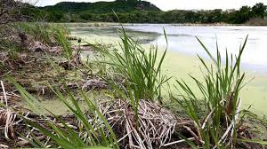
Wetlands must have three specific criteria to be classified as a wetland: hydric soils, hydrophytic vegetation, and hydrology. Photos play a strong supporting role in a wetland delineation. Photos of a project area can clearly support whether or not the three wetland criteria are present in an area.
Mobile Data Collection
Using their mobile devices, Westwood staff collect photos and data using the GeoJot+ field data collection app. The app automatically sends the files back to the office via the cloud. Collecting the information digitally with a set form means the data is consistent. The process also increases data accuracy by avoiding time-consuming manual transcription.
Reports and Other Output
Back in the office, staff process data using the GeoJot+ desktop app to create the necessary reports for their clients. They create word or .pdf reports which are often used as attachments to a larger wetland delineation report. They generate shapefiles in order to create maps for the reports and also for archiving purposes after a project is complete.
Managing users
Westwood can easily transfer the the GeoJot+ mobile app between devices. If someone forgets their company-provided iPad, they can transfer the app to their smartphone. An administrator can quickly transfer GeoJot+ to a new device if there is a change in staffing.
What’s next? Try GeoJot+ and download the engineering data collection forms.


