Learn how you can use a laser rangefinder with your smartphone or tablet for field data collection. Register for a free webinar presented by Laser Technology and GeoSpatial Experts next Wednesday April 10 at 1pm MDT.
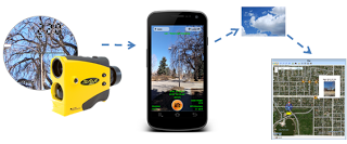
Use TruPulse lasers with your smartphones & tablets running GeoJot+ to wirelessly capture field data along with geotagged photos, automatically upload them to the cloud, then process them back in the office creating reports, maps and database input.
The days of measuring wheels, height sticks, pencils and a clipboard for recording field data are over. Attend this webinar and learn how to combine the power of an LTI’s TruPulse® mapping laser with your smartphone or tablet using the GeoJot+ app.


