Geotagged Photos Facilitate Requests for Federal Aid After Disasters
THORNTON, Colorado, USA, 26 January 2010 – Brown County, S.D., relies on GPS-enabled digital cameras and photo-mapping software to speed the deployment of resources and facilitate requests for federal assistance following natural disasters. The photo-mapping process, known as geotagging, utilizes GPS-Photo Link software from GeoSpatial Experts and the GPS-enabled Ricoh 500SE camera.
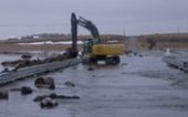
Roadway Breach. Photo courtesy of Brown County, South Dakota.
Brown County faces periodic spring flooding from snowmelt and heavy rains. As flood waters move across the county, officials acquire digital photos by air and by land with Ricoh 500SE cameras. A GPS receiver built onto each camera stamps the photos with precise coordinates of where each picture was taken. And a magnetic compass attached to the camera records the direction from which each photo was acquired.
The photos are uploaded along with their location data onto computers at the Brown County Emergency Operations Center. These computers run an easy-to-use photo-mapping software called GPS-Photo Link which automatically displays the photos in their correct geographic locations on a digital map of the county, either in a GIS or Google Earth environment.
County officials examine the photos to assess the damage and determine where emergency response teams should be deployed, explained Scott Madsen, County GIS Coordinator. The location coordinates on the photos help the responders quickly navigate back to those hardest hit areas. In addition, the county’s Emergency Management Director relies on the mapped photos to see where flood waters are headed so that resources can be sent downstream to warn the public and protect vital infrastructure.
Brown County has also discovered the geotagged photos are crucial for speeding their applications for disaster assistance from FEMA. Federal officials typically arrive to make their formal assessments after the flood waters have receded. The time- and location-stamped photos, however, provide them with exact records of the extent of damage that occurred in specific locations.
“When [FEMA] comes in to decide whether to declare a disaster for federal funding, they need to have documentation,” said Madsen. “They want to look at specific infrastructure damage…to put a dollar figure on it.”
Rick Bobbitt, President of GeoSpatial Experts, said that local government users of the GPS-Photo Link software are increasingly relying on geotagged photos taken during or shortly after a natural disaster to help determine the precise causes of damage. Rebuilding infrastructure to withstand future storms and floods depends on knowing whether damage was inflicted by winds, flood waters or floating debris. Brown County’s Madsen confirmed that these subtle differences can often be determined by mapping and examining geotagged photos of damage sites in the county GIS.
Utility Flooding. Photo Courtesy of Brown County, South Dakota.
The Brown County GIS Office has been so pleased with the geotagging technology that it has purchased additional GPS-enabled Ricoh cameras with magnetic compass modules for use in other county departments. Most notably, the county’s Zoning Department uses the cameras to document zoning violations and conduct site inspections.
While GPS-Photo Link is used in conjunction with the Ricoh 500 SE camera in Brown County, the photo-mapping software is compatible with any handheld GPS receiver and digital camera as well as some cell phones cameras with geotagging capabilities. The software can display the digital photos in most GIS and KML-based digital maps.
GeoSpatial Experts offers GPS-Photo Link in two editions: GPS-Photo Link GIS Pro for geospatial professionals mapping their photos in a true GIS environment, and GPS-Photo Link Express for business users who map photos on a digital or web-based map and generate reports from their photo inventories. GeoSpatial Experts sells the software as stand-alone packages or bundled with digital cameras and GPS receivers. To place an order, visit www.GeoSpatialExperts.com.
Contact:
Linda Bobbitt
GeoSpatial Experts
Phone: 303.255.2908
Email: [email protected]


